× Did you mean /sharing/rest/...?

You are using an unsupported version of this API located at https://maps.hamilton.govt.nz/portal/sharing. Avoid using and/or developing with this unsupported version. There are pitfalls in doing so and no advantages over using the released and supported version of the API, which is logically equivalent. The supported version is located at https://maps.hamilton.govt.nz/portal/sharing/rest/.
ArcGIS Portal Directory | Home Login | Signup | Generate Token
JSON | API Reference

Item (Image Mask)

Item Card (XML) | Package Info

ID 18a291917a2b49e88177e028d0b126ad
Item 18a291917a2b49e88177e028d0b126ad
Item Type text
Owner esri_en
Uploaded May 31, 2018
Modified May 31, 2018
Thumbnail
GUID N/A
Name N/A
Title Image Mask
Type Web Mapping Application
Type Keywords Configurable, createAppWithoutMap, interpret, JavaScript, Map, Mapping Site, Online Map, sourceId#8e3a6ab7b10c449bbfa0fa72b2b820af, Web Map
Description
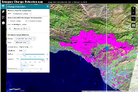
Image Mask is a configurable app template for identifying areas of an image that have changed over time or that meet user-set thresholds for calculated spectral indexes. The template also includes tools for measurement, recording locations, and more.

App users can zoom to bookmarked areas of interest (or search for their own), select any of the imagery layers from the associated web map to analyze, use a time slider or dropdown menu to select images, then choose between the Change Detection or Mask tools to produce results.

Image Mask users can do the following:
  • Zoom to bookmarked areas of interest (or bookmark their own)
  • Select specific images from a layer to visualize (search by date or another attribute)
  • Use the Change Detection tool to compare two images in a layer (see options, below)
  • Use the Mask tool to highlight areas that meet a user-set threshold for common spectral indexes (NDVI, SAVI, a burn index, and a water index). For example, highlight all the areas in an image with NDVI values above 0.25 to find vegetation.
  • Annotate imagery using editable feature layers
  • Perform image measurement on imagery layers that have mensuration capabilities
  • Export an imagery layer to the user's local machine, or as a layer in the user’s ArcGIS account
Use Cases
  • A student investigating urban expansion over time using Esri’s Multispectral Landsat image service
  • A farmer using NAIP imagery to examine changes in crop health
  • An image analyst recording burn scar extents using satellite imagery
  • An aid worker identifying regions with extreme drought to focus assistance
Change detection methods
For each imagery layer, give app users one or more of the following change detection options:
  • Image Brightness (calculates the change in overall brightness)
  • Vegetation Index (NDVI) (requires red and infrared bands)
  • Soil-Adjusted Vegetation Index (SAVI) (requires red and infrared bands)
  • Water Index (requires green and short-wave infrared bands)
  • Burn Index (requires infrared and short-wave infrared bands)
For each of the indexes, users also have a choice between three modes:
  • Difference Image: calculates increases and decreases for the full extent
  • Difference Mask: users can focus on significant change by setting the minimum increase or decrease to be masked—for example, a user could mask only areas where NDVI increased by at least 0.2
  • Threshold Mask: The user sets a threshold and magnitude for what is masked as change. The app will only identify change that’s above the user-set lower threshold and bigger than the user-set minimum magnitude.

Supported Devices
This application is responsively designed to support use in browsers on desktops, mobile phones, and tablets.

Data Requirements
Creating an app with this template requires a web map with at least one imagery layer.

Get Started 
This application can be created in the following ways:
  1. Click the Create a Web App button on this page
  2. Share a map and choose to create a web app
  3. On the Content page, click Create - App - From Template
  4. Click the Download button to access the source code. Do this if you want to host the app on your own server and optionally customize it to add features or change styling.


Tags ArcGIS web application template
Snippet Creates an app to calculate and visualize change between two images in an imagery layer.
Extent N/A
Spatial Reference N/A
Access Information N/A
License Information N/A
Culture en
Properties N/A
Url /apps/ImageMask/index.html
Proxy Filter N/A
Last Modified N/A
Size 13605
Documentation N/A
App Categories N/A
Industries N/A
Languages N/A
Screenshots screenshots/change_1.png
Listed false
Comments Enabled true
# Comments 0
# Ratings 0
Avg. Rating 0.0
# Views 68
Categories
Content Status


Child Resources:   Comments   Rating   Groups   Item Data   Item Data as Zip   Item Dependencies

Supported Operations:   Add Comment   Add Rating   Delete Rating   Related Items   Share Item   Unshare Item   Package Item   Set Item Content Status