Item (Curvature)
Item Card (XML) | Package Info| ID | 2230dd1af879431c869e3f16639e5037 |
| Item | Curvature.rft.json |
| Item Type | file |
| Owner | esri_en |
| Uploaded | Nov 15, 2018 |
| Modified | Nov 15, 2018 |
| Thumbnail |
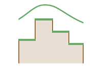
|
| GUID | N/A |
| Name | N/A |
| Title | Curvature |
| Type | Raster function template |
| Type Keywords | ArcGIS Raster Function Templates, categoryName#SurfaceSystem_RFT, Function Template, Functions, Processing, Raster, rft, sourceId#CurvatureSystem_RFT, Templates |
| Description | The Curvature function displays the shape or curvature of the slope. A part of a surface can be concave or convex; you can tell that by looking at the curvature value. The curvature is calculated by computing the second derivative of the surface. The output of the Curvature function can be used to describe the physical characteristics of a drainage basin in an effort to understand erosion and runoff processes. The curvature value can be used to find soil erosion patterns as well as the distribution of water on land. The profile curvature affects the acceleration and deceleration of flow and, therefore, influences erosion and deposition. The planform curvature influences convergence and divergence of flow. |
| Tags | System Raster Function, Raster Function Template, Surface, Curvature |
| Snippet | Calculates the curvature of a raster surface, optionally including profile and plan curvature. |
| Extent | N/A |
| Spatial Reference | N/A |
| Access Information | Esri, Inc. |
| License Information | This raster function template may be used to process your imagery using ArcGIS Image Server. |
| Culture | english (united states) |
| Properties | N/A |
| Url | N/A |
| Proxy Filter | N/A |
| Last Modified | N/A |
| Size | 1098 |
| Documentation | N/A |
| App Categories | N/A |
| Industries | N/A |
| Languages | N/A |
| Listed | false |
| Comments Enabled | true |
| # Comments | 0 |
| # Ratings | 0 |
| Avg. Rating | 0.0 |
| # Views | 335 |
| Categories | |
| Content Status |
Child Resources: Comments Rating Groups Item Data Item Data as Zip Item Dependencies
Supported Operations: Add Comment Add Rating Delete Rating Related Items Share Item Unshare Item Package Item Set Item Content Status