Item (Segment Mean Shift)
Item Card (XML) | Package Info| ID | 8025c8f159c9401d9dcf570a45216873 |
| Item | Segment_Mean_Shift.rft.json |
| Item Type | file |
| Owner | esri_en |
| Uploaded | Nov 15, 2018 |
| Modified | Nov 15, 2018 |
| Thumbnail |
|
| GUID | N/A |
| Name | N/A |
| Title | Segment Mean Shift |
| Type | Raster function template |
| Type Keywords | ArcGIS Raster Function Templates, categoryName#ClassificationSystem_RFT, Function Template, Functions, Processing, Raster, rft, sourceId#Segment Mean ShiftSystem_RFT, Templates |
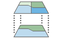
| Description | This function identifies objects, features, or segments in your imagery by grouping adjacent pixels together that have similar spectral and spatial characteristics. You can control the amount of spatial and spectral smoothing to help derive features of interest. |
| Tags | System Raster Function, Raster Function Template, Classification, Segment Mean Shift |
| Snippet | Groups neighboring pixels with similar spectral characteristics together into segments. |
| Extent | N/A |
| Spatial Reference | N/A |
| Access Information | Esri, Inc. |
| License Information | This raster function template may be used to process your imagery using ArcGIS Image Server. |
| Culture | english (united states) |
| Properties | N/A |
| Url | N/A |
| Proxy Filter | N/A |
| Last Modified | N/A |
| Size | 1581 |
| Documentation | N/A |
| App Categories | N/A |
| Industries | N/A |
| Languages | N/A |
| Listed | false |
| Comments Enabled | true |
| # Comments | 0 |
| # Ratings | 0 |
| Avg. Rating | 0.0 |
| # Views | 344 |
| Categories | |
| Content Status |
Child Resources: Comments Rating Groups Item Data Item Data as Zip Item Dependencies
Supported Operations: Add Comment Add Rating Delete Rating Related Items Share Item Unshare Item Package Item Set Item Content Status