Item (Raster Analytics: Count features in satellite images)
Item Card (XML) | Package Info| ID | b6ef1a796dbc432094b0b3a774d4e07e |
| Item | counting_features_in_satellite_images_using_scikit_image.ipynb |
| Item Type | file |
| Owner | esri_notebook |
| Uploaded | Apr 25, 2019 |
| Modified | Apr 25, 2019 |
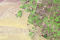
| Thumbnail |
|
| GUID | N/A |
| Name | N/A |
| Title | Raster Analytics: Count features in satellite images |
| Type | Notebook |
| Type Keywords | Notebook, Python |
| Description | Given a Landat image, we count the number of center pivots through Difference of Gaussian method using scikit-image library. |
| Tags | Raster Analysis, scikit-image, image segmentation, satellite imagery |
| Snippet | Count the number of center pivots farms using scikit-image. |
| Extent | N/A |
| Spatial Reference | N/A |
| Access Information | N/A |
| License Information | N/A |
| Culture | english (united states) |
| Properties | {"notebookRuntimeName":"ArcGIS Notebook Python 3 Standard","notebookRuntimeVersion":"10.7.1"} |
| Url | N/A |
| Proxy Filter | N/A |
| Last Modified | N/A |
| Size | 2991600 |
| Documentation | N/A |
| App Categories | N/A |
| Industries | N/A |
| Languages | N/A |
| Listed | false |
| Comments Enabled | true |
| # Comments | 0 |
| # Ratings | 0 |
| Avg. Rating | 0.0 |
| # Views | 261 |
| Categories | Data Science and Analysis |
| Content Status |
Child Resources: Comments Rating Groups Item Data Item Data as Zip Item Dependencies
Supported Operations: Add Comment Add Rating Delete Rating Related Items Share Item Unshare Item Package Item Set Item Content Status