Item (Imagery Viewer)
Item Card (XML) | Package Info| ID | e867157eafe24ced8f3dbfeeeb288f27 |
| Item | e867157eafe24ced8f3dbfeeeb288f27 |
| Item Type | text |
| Owner | esri_en |
| Uploaded | May 31, 2018 |
| Modified | May 31, 2018 |
| Thumbnail |
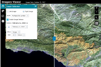
|
| GUID | N/A |
| Name | N/A |
| Title | Imagery Viewer |
| Type | Web Mapping Application |
| Type Keywords | Configurable, createAppWithoutMap, interpret, JavaScript, Map, Mapping Site, Online Map, sourceId#ffb43b6e9ef14537821a983d1c7b447f, Web Map |
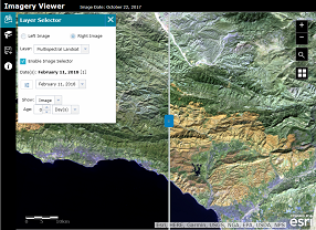
| Description | Imagery Viewer is a configurable app template for visualizing and exploring imagery through time and space, and includes tools for navigating through time, recording locations, measurement, and more. A one-image configuration lets users focus on a single imagery layer, while a two-image configuration lets users compare two imagery layers using a swipe tool. Imagery Viewer users can do the following:
Use Cases
Supported Devices This application is responsively designed to support use in browsers on desktops, mobile phones, and tablets. Data Requirements Creating an app with this template requires a web map with at least one imagery layer. Get Started This application can be created in the following ways:
|
| Tags | ArcGIS web application template |
| Snippet | Creates an app to better visualize and interpret imagery layers through time and space. |
| Extent | N/A |
| Spatial Reference | N/A |
| Access Information | N/A |
| License Information | N/A |
| Culture | en-us |
| Properties | N/A |
| Url | /apps/ImageryViewer/index.html |
| Proxy Filter | N/A |
| Last Modified | N/A |
| Size | 12980 |
| Documentation | N/A |
| App Categories | N/A |
| Industries | N/A |
| Languages | N/A |
| Screenshots |
screenshots/ImageView_1.png |
| Listed | false |
| Comments Enabled | true |
| # Comments | 0 |
| # Ratings | 0 |
| Avg. Rating | 0.0 |
| # Views | 264 |
| Categories | |
| Content Status |
Child Resources: Comments Rating Groups Item Data Item Data as Zip Item Dependencies
Supported Operations: Add Comment Add Rating Delete Rating Related Items Share Item Unshare Item Package Item Set Item Content Status